Atchampet: A Town and Mandal in Guntur district
District → Guntur
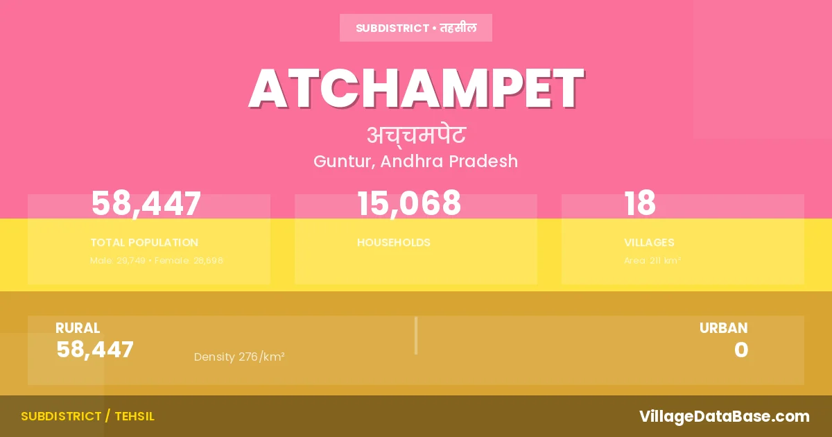
State → Andhra Pradesh
Atchampet is a town and Mandal in the Guntur district of the Andhra Pradesh. In India, a Mandal is a subdivision of a district responsible for the administration and revenue collection of a specific area within the district. Mandals play a crucial role in the local governance structure, contributing significantly to the development and administration of their communities.
According to the 2011 census The total area of Atchampet Mandal is 211 km², with a population of 58447 people. The population density is 276 inhabitants per square kilometre, and there are approximately 15068 houses in the sub district.
Atchampet Mandal comprises about 18 villages. Below is a list of these villages along with information about their respective gram panchayats and the nearest town:
| # | Village Name | Gram Panchayat | Nearest Town |
|---|---|---|---|
| 1 | Ambadipudi | Ambadipudi | Sattenapalle (35 km) |
| 2 | Challagariga | Challagariga | Sattenapalle (50 km) |
| 3 | Chamarru | Atchampeta | Sattenapalle (28 km) |
| 4 | Chigurupadu | Chigurupadu | Sattenapalle (28 km) |
| 5 | Chintapalle | Cherukupalem | Sattenapalle (42 km) |
| 6 | Ginjupalle | Madipadu | Sattenapalle (51 km) |
| 7 | Kastala Agraharam | Kastala | Sattenapalle (26 km) |
| 8 | Kogantivaripalem | Kogantivaripalem | Sattenapalle (29 km) |
| 9 | Konduru | Konduru | Sattenapalle (30 km) |
| 10 | Konuru | Konuru | Sattenapalle (29 km) |
| 11 | Madipadu Agraharam | Madipadu | Sattenapalle (60 km) |
| 12 | Madipadu Seri | Madipadu | Sattenapalle (60 km) |
| 13 | Mittapalem | Mittapalem | Sattenapalle (26 km) |
| 14 | Orvakallu | Grandhasiri | Sattenapalle (30 km) |
| 15 | Pedapalem | Pedapalem | Sattenapalle (25 km) |
| 16 | Taduvoy | Taduvoy | Sattenapalle (46 km) |
| 17 | Tallacheruvu | Kothapalli | Sattenapalle (32 km) |
| 18 | Velpuru | Velpur | Sattenapalle (23 km) |
The population is distributed between urban and rural areas as follows:
| Particulars | Rural | Urban | Total |
|---|---|---|---|
| Total Population | 58447 | 0 | 58447 |
| Male Population | 29749 | 0 | 29749 |
| Female Population | 28698 | 0 | 28698 | Population Density | 276 / km² | 276 / km² |
The distribution of households in the Atchampet is:
| Rural Households | Urban Households | Total Households |
|---|---|---|
| 15068 | 0 | 15068 |
Q: What is Atchampet?
A: Atchampet is a town and in the Guntur district of the Andhra Pradesh.
Q: What is the total area of Atchampet Mandal?
A: The total area of Atchampet Mandal is 211 km².
Q: What is the population of Atchampet Mandal according to the 2011 census?
A: According to the 2011 census, the population of Atchampet Mandal is 58447.
Q: What is the population density of Atchampet Mandal?
A: The population density of Atchampet Mandal is 276 inhabitants per square kilometre.
Q: How many houses are there in Atchampet Mandal?
A: There are approximately 15068 houses in Atchampet Mandal.
Q: How many villages are there in Atchampet Mandal?
A: There are about 18 villages in Atchampet Mandal.
Q: Which is the largest village by population in Atchampet Mandal?
A: The largest village by population in Atchampet Mandal is Chamarru, with 12232 people.
Q: Which is the smallest village by population in Atchampet Mandal?
A: The smallest village by population in Atchampet Mandal is Madipadu Seri, with 900 people.
Q: Which is the largest village by area in Atchampet Mandal?
A: The largest village by area in Atchampet Mandal is Chamarru, with 2720 km².
Q: Which is the smallest village by area in Atchampet Mandal?
A: The smallest village by area in Atchampet Mandal is Madipadu Agraharam, with 218 km².
Q: What is the population distribution between urban and rural areas in Atchampet Mandal?
A: The population distribution in Atchampet Mandal is entirely rural, with a total rural population of 58447.
Q: What is the male population of Atchampet Mandal?
A: The male population of Atchampet Mandal is 29749.
Q: What is the female population of Atchampet Mandal?
A: The female population of Atchampet Mandal is 28698.
Q: How is the household distribution in Atchampet Mandal?
A: The household distribution in Atchampet Mandal is entirely rural, with a total of 15068 households.
Q: How many villages in Atchampet Mandal have a population between 500 and 999?
A: There are 4 villages in Atchampet Mandal with a population between 500 and 999.
Q: How many villages in Atchampet Mandal have a population between 1000 and 1999?
A: There are 4 villages in Atchampet Mandal with a population between 1000 and 1999.
Q: How many villages in Atchampet Mandal have a population between 2000 and 2999?
A: There is 2 village in Atchampet Mandal with a population between 2000 and 2999.
Q: How many villages in Atchampet Mandal have a population between 3000 and 3999?
A: There is 2 village in Atchampet Mandal with a population between 3000 and 3999.
Q: How many villages in Atchampet Mandal have a population between 4000 and 4999?
A: There is 4 village in Atchampet Mandal with a population between 4000 and 4999.
Q: How many villages in Atchampet Mandal have a population of 5000 and above?
A: There is 2 village in Atchampet Mandal with a population of 5000 and above.
| Total Population | Villages in Sub District Of Atchampet |
|---|---|
| 500-999 | 4 |
| 1000-1999 | 4 |
| 2000-2999 | 2 |
| 3000-3999 | 2 |
| 4000-4999 | 4 |
| 5000 And Above | 2 |